


[Making Achievements in a New Era, Striving Forward on a New Journey] — A Detailed Look at Kanshe’s Municipal Works (Part 2)
Release time:
2023-02-07 11:51
Source:
Editor's Note
Municipal roads are the lifeblood of a city—when the lifeblood flows smoothly, the city thrives. In recent years, under the leadership of the great Communist Party of China, surveyors and designers have leveraged their accumulated technological and talent advantages in the highway sector to actively expand their surveying and design services into the municipal engineering field, thus weaving one prosperous avenue after another that connects cities to their dreams and striving to unblock the city’s “Ren and Du” meridians.
Today we’re launching “ [ Achieve Meritorious Deeds in the New Era Forge ahead on a new journey 】 —A Detailed Look at the Municipal Section of Kan She’s Works (Part 2)—Engineering Design for the Tuan Yuan Shan Ring Road Construction Project in Xifeng County.
Engineering Design for the Qiyuan Mountain Ring Road Construction Project in Xifeng County
Project Overview
The starting point of the Tuanyuan Mountain Loop in Xifeng County is located in Laojie Village, Yongjing Town, and the ending point is at No. 2 Road in the Pingshang Industrial Park. This loop encircles Xifeng’s “green lung,” Tuanyuan Mountain, forming a closed loop that connects Xifeng County town with the Yanglang area and the Xishan Town area. The route has a total length of 11.93 kilometers. Designed to the standard of a two-way, six-lane urban arterial road. 60 kilometers per hour The subgrade width is 40 meters, and the road was completed and opened to traffic in August 2019.
The Tuanyuan Mountain Ring Road is a key urban arterial road in Xifeng County, serving as the main axis for the county’s “southward shift and westward expansion” and acting as the vital artery for industrial clustering. The project is large-scale and features complex construction conditions, presenting numerous challenging engineering issues that need to be addressed. Adhering to the principles of green and low-carbon development, the design leverages BIM technology and Internet+ solutions to create a landmark road for Xifeng County.

Natural transition between road design and native vegetation
Technical Features
(1) Address the technical challenges in constructing urban roads in mountainous areas under complex conditions by adopting green and low-carbon design approaches, thereby achieving integration between urban development and tourism.
The project crosses over the Gui-Zun Expressway, with a height difference of up to 55 meters. The design incorporates an ultra-high temporary protective canopy, and the structural design takes into full consideration factors such as wind resistance, anti-overturning stability, and the significant impact forces posed by falling objects from high altitudes, thereby ensuring driving safety on the Gui-Zun Expressway. In the early stages of the design, extensive surveys were conducted in the foggy areas of Guizhou, revealing that dense fog clusters in this region are concentrated at an elevation of around 980 meters. Consequently, along the Xifeng Bridge section, the design elevation of the route was raised to above 1,030 meters, effectively avoiding the canyon area where fog tends to concentrate and thus preventing traffic accidents caused by heavy fog after the road is opened to traffic. The route intersects with Sinopec’s oil pipeline at two locations. For the first time in municipal roads within the province, this project employs an arch-shaped corrugated steel plate structure with an 8-meter span to cross over the oil pipeline—ensuring both safety and meeting the future maintenance requirements of the pipeline.
In terms of route design, based on urban road network planning and taking into account topography, landforms, and geological conditions, several alternative schemes have been proposed for detailed study and evaluation. While ensuring that the urban roads meet traffic and service requirements, ecological protection technologies have been applied to strengthen the preservation of natural landforms and native vegetation. This approach has resulted in a saving of 48,117 tons of standard coal and reduced CO₂ emissions. 2 Emissions amount to approximately 104,361 tons. The route was selected based on urban planning to ensure an appropriate planar location, and its subgrade elevation is seamlessly connected to the Dizhai Tourism Reception and Service Center, thereby achieving integration between urban development and tourism.
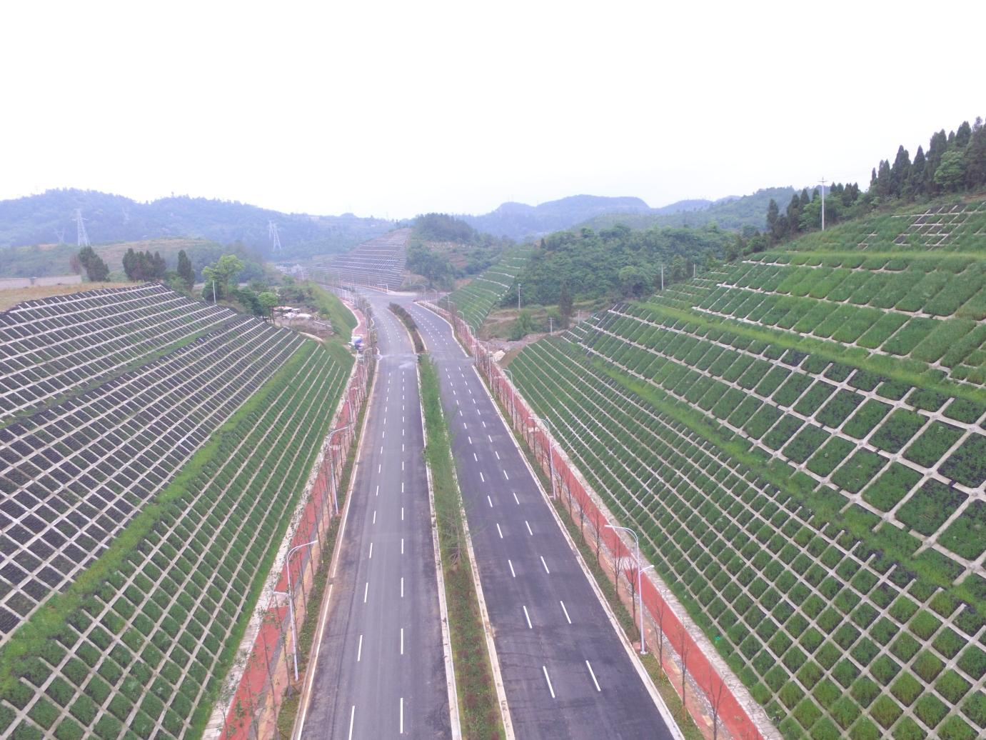
A five-colored ribbon formed by the road

(2) The integrated application of BIM technology and Internet+ technology to the Xifeng Bridge represents a provincial first.
Xifeng Bridge is the key project of the Tuanyuan Mountain Ring Road Construction Project in Xifeng County. It spans the Xifeng River and the Gui-Zun Expressway. The main bridge is a continuous rigid-frame bridge with spans of 96.5 meters + 180 meters + 96.5 meters, with a total length of 1,012 meters and a height of 130 meters. Among municipal bridges of similar types within the province, this bridge boasts the longest main span and the greatest height. For the first time in the province, BIM technology combined with “Internet Plus” technology has been applied in engineering practice, effectively addressing the challenges of long construction periods and complex construction organization.
The main bridge’s cross-section is a single-box, single-chamber structure with variable depth. Due to its large dimensions, it is difficult to clearly depict the spatial relationships among the three-dimensional prestressing forces, prestressing ducts, and reinforcement bars using conventional 2D methods. By adopting parametric modeling for the structural components, we can achieve a three-dimensional visual design and establish interaction rules governing the relationships among various components and their characteristics. Furthermore, by leveraging entity model identification coding technology, we can develop a retrieval and visualization mechanism.
The bridge employs cantilevered basket-type cast-in-place construction. Since it spans both the Xifeng River and the Gui-Zun Expressway simultaneously, the construction process is highly complex. In this project, we leveraged Clash Detection technology to enable BIM-based clash detection and component collision checks for the prestressed concrete continuous steel structure and continuous T-beam superstructure of the bridge. This approach provides a 4D visualization of the construction schedule, allowing us to predict the next stage of construction and ensure that the project stays on track.

The integration and coordination of Xifeng Bridge with the Gui-Zun Expressway and the Xifeng River.
Meaning and Effectiveness
The completion of this project effectively connects the Xifeng Yongjing cluster, Yanglang cluster, and Xishan cluster urban belts. While enhancing Xifeng’s infrastructure and elevating its urban image, it also promotes the integrated development of Xifeng County town, laying a solid foundation for advancing new-type urbanization with mountainous characteristics and establishing a rapid transportation system for Guiyang City. Relying on this project, we have achieved two technological breakthroughs, published three papers, obtained one construction method, and secured six patents. Furthermore, we were awarded the First Prize of the “2020 Guizhou Province Outstanding Survey and Design Award” by the Guizhou Provincial Engineering Survey and Design Association.
--Kan She Co., Ltd.--
Planning: Technical Quality Department
Editor: Zhao Jing
First instance: Shao Dan
Second Instance: Yan Xia
Final Review: Wu Dahong
-
File size: 200
Related News
Address: No. 100, Yangguan Avenue, National High-tech Industrial Development Zone, Guiyang City, Guizhou Province


mobile client


